Ancient Martian Riverbeds: Uncovering the Timeline of Water on the Red Planet
Mars, our celestial neighbor, continues to captivate scientists and space enthusiasts alike. Recent discussions between NASA officials and congressional representatives have highlighted intriguing questions about the timeline of Martian geological features. While NASA maintains that significant water features on Mars existed billions of years ago, this timeline raises important questions about the survival of these features through countless dust storms and erosion processes.
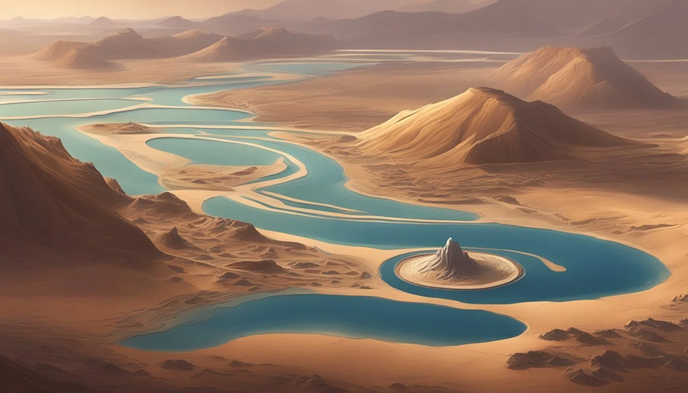
The red planet shows evidence of ancient rivers, lakes, and water channels spanning tremendous distances across its surface. These features range from massive thousand-mile-long river beds to smaller stream channels scattered throughout the landscape. Despite the presence of ice at the Martian poles and occasional evidence of current water activity, explaining how smaller water features could remain visible after billions of years of 70 mph dust storms covering the entire planet presents a fascinating scientific puzzle.
Key Takeaways
Mars shows evidence of water features that raise questions about their survivability through billions of years of erosion.
Frequent planet-wide dust storms significantly alter the Martian landscape, casting doubt on extremely ancient timelines.
NASA's official position about Mars' watery past may warrant further scientific scrutiny and investigation.
Discrepancies in Mars' Geographic Timeline

Timeframe Conflict: Ages or Millennia
The debate over Mars' geological history centers on a critical timing question. NASA consistently states that evidence of oceans, lakes, and rivers on Mars dates back 3-4 billion years. However, this timeline raises significant questions about preservation. Mars experiences frequent dust storms reaching tropical storm strength (approximately 70 mph), capable of completely altering surface features. These storms often blanket the entire planet and continue for days, causing substantial terrain modifications even after a single event.
If one storm can dramatically reshape the landscape, how could water channels, riverbeds, and lake basins survive billions of years of such events? The number of storms over such a timeframe would reach into the tens of billions. Even massive geological features would face significant erosion and alteration.
The polar ice caps on Mars show seasonal variations, and some ice exists in mountain ranges and craters. However, this doesn't explain how water channels thousands of miles from any ice source could remain visible after billions of years of wind erosion.
Congressional Questioning
In July 2025, Representative Rohrabacher raised this timeline inconsistency during a NASA hearing. When the congressman specifically mentioned "thousands of years ago," the NASA executive immediately corrected him, stating "billions of years ago" without addressing the preservation problem.
The exchange highlighted a critical issue:
NASA Executive: "The evidence is that Mars was different billions of years ago..." Rep. Rohrabacher: "You have indicated that Mars was totally different thousands of years ago."
This discrepancy remains unresolved. The executive didn't provide evidence supporting how geological features could survive billions of years of storms and erosion. A more realistic timeframe for many visible Martian surface features might be measured in thousands rather than billions of years.
Some large-scale features, like the massive river channel measuring nearly 1,000 miles long, 1,000 feet deep, and 4.5 miles across, might reasonably survive longer periods. However, smaller features like creek beds and narrow channels would likely be completely erased by the countless dust storms over millions or billions of years.
Mars' Geological History and Preservation
Terrain Persistence Despite Erosion
The survival of geological features on Mars raises intriguing questions about their age. NASA has traditionally dated many Martian surface features to 3-4 billion years ago, but this timeline deserves closer examination. The planet experiences routine dust storms reaching tropical storm strength (approximately 70 mph), which significantly alter the landscape. These massive weather events often blanket the entire planet and can last for days, creating visible changes to the surface after just a single occurrence.
Evidence of this rapid landscape alteration can be observed in comparative satellite imagery taken before and after Martian storms. If one storm can so dramatically reshape areas of the surface, the cumulative effect of thousands or potentially millions of such events over billions of years would logically erase or significantly degrade most geological features. This raises reasonable doubts about the extreme age estimates for many Martian surface features.
Water Formations and Ice Deposits
Mars displays numerous signs of past water activity across its surface, from massive channels to smaller stream-like formations. Some of these water channels are impressive in scale—nearly 1,000 miles long, 1,000 feet deep, and 4.5 miles across. While larger formations might reasonably withstand extensive erosion, the preservation of smaller stream beds and creek-like channels over billions of years seems less plausible given the planet's harsh conditions.
The red planet does show evidence of water today, primarily in the form of ice caps at the north and south poles. These polar ice formations visibly change with the Martian seasons. Additional ice deposits exist in various mountain ranges and crater areas, but they don't explain the well-preserved water channels located thousands of miles from any current ice sources.
The disconnect between where water currently exists on Mars and where water channels appear across the planet presents a timing puzzle. These water-carved features, especially the smaller ones, would struggle to survive the relentless cycle of planet-wide dust storms over the immense timeframes suggested. A more recent formation of these features would better explain their current state of preservation.
Current Evidence of Water on Mars

Mars continues to reveal fascinating insights about its hydrological features, challenging earlier assumptions about the planet's geological history. Recent observations suggest water presence may be more recent than previously acknowledged, with compelling physical evidence persisting despite Mars' harsh environment.
Polar Ice Caps and Seasonal Variations
The Martian poles provide the most obvious evidence of water on the planet today. Both the north and south polar regions contain substantial ice caps that undergo visible seasonal changes throughout the Martian year. These changes can be observed from orbit, with ice expanding during winter months and receding during warmer periods.
North Pole: Contains primarily water ice that expands and contracts seasonally
South Pole: Features a mix of water ice and carbon dioxide ice (dry ice)
Seasonal patterns: Clearly documented through satellite imagery
These polar ice formations represent significant water reservoirs on the planet's surface. Satellite monitoring has documented these cyclical changes, providing strong evidence of active water-ice processes rather than static, ancient formations.
Mountain Deposits and Crater Accumulations
Beyond the poles, evidence of water ice exists in various mountain ranges and impact craters across the Martian landscape. These isolated deposits appear in regions where environmental conditions permit ice stability, often in permanently shadowed areas.
Ice deposits have been identified in:
High-elevation mountain ranges
Deep crater floors
Areas shielded from direct sunlight
Unlike the extensive water channels found thousands of miles from current ice sources, these deposits represent modern water accumulations. Their presence contradicts the notion that all Martian water features date back billions of years. The persistent nature of these ice formations raises questions about how ancient water features could survive the same environmental conditions that reshape the planet's surface today.
The existence of these mountain and crater ice deposits, combined with the dynamic polar ice caps, suggests Mars maintains an active—albeit limited—hydrological system in the present era rather than solely in the distant past.
Impact of Martian Dust Storms

Storm Intensity and Coverage
Martian dust storms reach tropical storm strength with winds up to 70 miles per hour. These massive weather events often blanket significant portions of the planet, sometimes covering Mars entirely.
Satellite imagery reveals the true scale of these phenomena, which can persist for days at a time. Unlike the hurricane-force storms depicted in popular media, these are more comparable to strong tropical storms on Earth.
The visual impact of these storms is striking when viewed from orbit:
Storm Characteristic Description Wind Speed Approximately 70 mph Duration Hours to multiple days Coverage Can encompass the entire planet Frequency Multiple occurrences yearly
Surface Alteration Over Time
A single Martian dust storm can dramatically transform the planet's landscape. Photographic evidence shows significant terrain changes following just one storm event.
These alterations raise questions about the preservation of surface features over extended periods. Large-scale formations like ancient riverbeds—some measuring nearly 1,000 miles in length, 1,000 feet in depth, and 4.5 miles across—would face countless erosion cycles from dust storms.
The preservation of smaller features is particularly puzzling:
Major waterways: While massive river channels might withstand substantial erosion
Minor features: Smaller creek beds and stream marks would be more vulnerable
Distance factors: Features thousands of miles from existing ice sources present conservation challenges
The frequency of these storms compounds their erosive impact. With multiple storms occurring yearly, the cumulative effect over centuries or millennia would be substantial, suggesting that visible surface features today likely couldn't remain intact through millions or billions of years of continuous erosion.
NASA's Mars Timeline Controversy
NASA's official position on Mars' geological history has sparked debate among space enthusiasts and some congressional representatives. The agency consistently maintains that significant water features on Mars date back 3-4 billion years, but questions remain about how such terrain features could survive countless dust storms and erosion processes over such an immense timeframe.
Questioning Ancient Timescales
NASA executives have repeatedly stated that Mars was significantly different "billions of years ago," specifically 3-4 billion years in the past. This timeframe has been challenged during congressional hearings, where representatives have questioned whether some Martian features might be much younger. When directly questioned about potential evidence from "thousands of years ago" rather than billions, NASA officials appeared to dismiss shorter timeframes without providing detailed justification for their certainty about billion-year timescales.
The agency's confidence in these ancient dates raises important questions:
How are precise timeframes established without direct sample dating?
What methodology supports claims of specifically 3-4 billion years rather than 1 billion or 500 million?
Why is there apparent resistance to considering shorter timeframes?
Satellite imagery shows Martian dust storms regularly reshape surface features, with single storms capable of dramatically altering terrain. This observable process makes the preservation of delicate water channels over billions of years seem scientifically questionable.
The Limits of Rover Exploration
The current exploration methods have significant limitations in establishing precise geological timelines. Rovers can only analyze surface materials in limited locations with restricted testing capabilities. Without human presence or advanced drilling technologies, determining exact ages remains challenging.
NASA's evidence includes massive river channels approximately:
1,000 miles long
1,000 feet deep
4.5 miles across
While these larger features might potentially survive extensive periods, smaller water channels, stream beds, and creek formations present across Mars would likely have been completely erased by the estimated tens of billions of dust storms that would have occurred over a multi-billion-year timeframe.
Current Mars exploration shows evidence of water existing today in specific forms:
Current Water Evidence Location Ice caps North and South Poles Seasonal changes Polar regions Scattered ice deposits Various mountain ranges and craters
These present-day water features exist thousands of miles from many of the water channels NASA attributes to ancient processes, creating a geographical disconnect that raises questions about the agency's timeline assertions.
Martian dust storms reach tropical storm strength (approximately 70 mph) and frequently cover the entire planet for days, creating environmental conditions that would significantly impact surface preservation over extended periods.
Analyzing Surface Formations
The Martian landscape contains numerous geological features that raise important questions about their age and formation processes. Evidence of water-shaped terrain exists across Mars, yet the timeframes suggested for their creation seem at odds with their remarkable preservation state.
Major Valley Networks
Valley networks spanning significant distances across Mars present intriguing evidence about the planet's hydrological past. One particularly notable formation extends nearly 1,000 miles in length, measures 1,000 feet in depth, and spans approximately 4.5 miles across. Such massive features might reasonably withstand extended periods of erosion.
However, the preservation state of these large-scale formations raises questions about their purported age. Given the frequent dust storms that sweep across Mars—often reaching tropical storm strength with winds of approximately 70 mph—one would expect significant degradation over extended timeframes. These storms can envelop the entire planet and dramatically alter surface features in a single event.
The suggestion that these massive valley networks have remained largely intact for 3-4 billion years deserves critical examination. The erosional forces of countless dust storms over such an extended period would likely have significantly modified or obliterated many of these features.
Smaller Watercourses
The smaller-scale water channels present an even more puzzling scenario regarding Martian geological history. These narrow formations, resembling earthly creeks and streams, appear remarkably well-preserved despite their relatively delicate structure.
Many of these smaller watercourses exist thousands of miles from any current ice deposits on Mars. While ice is clearly present at the Martian poles and in certain crater and mountain regions, these distant water channels lack any obvious current water source.
The preservation of these finer details in the Martian landscape becomes increasingly difficult to reconcile with timescales measuring in billions of years. Features of this scale would be particularly vulnerable to:
Regular planetary dust storms
Wind erosion
Sediment redistribution
Temperature fluctuations
Satellite imagery demonstrates that even a single Martian storm can substantially transform the planet's surface characteristics. Multiplied across thousands or millions of years, such forces would likely erase or significantly alter these smaller watercourse features, suggesting their formation might have occurred more recently than commonly stated.
Evidence Challenging NASA's Mars Timeline
Congressman Rohrabacher's Critical Inquiry
During a congressional hearing in July 2024, Representative Dana Rohrabacher raised a significant question about Mars' historical timeline that NASA officials appeared reluctant to address directly. When Rohrabacher questioned whether Mars might have been "totally different thousands of years ago" rather than billions, the NASA executive pivoted to their standard narrative without providing substantive evidence for their timeline claims.
The exchange highlights a crucial discrepancy in the scientific narrative. Rather than engaging with the question about a more recent timeframe for Martian geological features, the NASA representative immediately defaulted to the "billions of years ago" position without presenting clear justification for dismissing alternative timeframes.
Geological Features Unexplained by Ancient Origin Theory
The persistence of water-carved channels across Mars presents a significant challenge to NASA's timeline. These features would have had to survive billions of years of severe erosion forces, including:
Routine dust storms reaching 70 mph (tropical storm strength)
Planet-wide weather events lasting days
Dramatic surface alterations documented after single storm events
Photographic Evidence Contradictions:
Feature Type NASA Timeline Logical Concern Major river channels 3-4 billion years old 1,000+ mile features with sharp edges despite billions of erosion events Small streams/creeks 3-4 billion years old Fine details preserved despite being more vulnerable to erosion Water channels 3-4 billion years old Located thousands of miles from current ice deposits
Satellite imagery confirms that even single Martian storms significantly transform surface features. The mathematical probability of delicate geological formations surviving tens of billions of such events while maintaining recognizable characteristics defies reasonable explanation.
While larger features like the documented river channel (1,000 miles long, 1,000 feet deep, and 4.5 miles across) might withstand considerable erosion, the preservation of smaller water features across billions of years contradicts basic principles of geological degradation. A timeline measured in thousands rather than billions of years provides a more plausible explanation for the current state of these formations.
NASA's dating methodology for these features deserves greater scrutiny, particularly since direct testing capabilities remain limited by rover technology constraints. The agency has yet to adequately explain how they established such precise ancient dates without human presence for comprehensive testing and analysis.
Questioning NASA's Timeline of Mars
The Martian landscape presents compelling questions about NASA's timeline of water existence on the Red Planet. While NASA maintains that water features on Mars date back 3-4 billion years, this timeline faces significant logical challenges when examining the planet's ongoing geological processes.
Mars experiences regular sandstorms of tropical storm strength (approximately 70 mph) that can engulf the entire planet. These massive weather events dramatically alter the Martian surface even after a single occurrence. The visible changes to terrain features after just one storm raise legitimate questions about how delicate water channels could survive billions of years of such activity.
The preservation of detailed water features is particularly puzzling. While massive formations like the thousand-mile river channel (nearly 1,000 feet deep and 4.5 miles across) might withstand significant erosion, smaller streams and creek beds should have disappeared long ago if they truly dated back billions of years.
Evidence challenging the billion-year timeline:
Regular planet-wide sandstorms dramatically reshape the surface
Visible terrain changes occur after single storm events
Tens of billions of storms would have occurred over the proposed timeline
Smaller water channels remain visible despite erosion forces
The continued existence of these features, especially those thousands of miles from any current ice source, suggests a much more recent timeline measured in thousands—not billions—of years. This discrepancy between NASA's official position and observable evidence invites further questioning about our understanding of Mars' geological history.
Further Exploration Topics
Notable Inconsistencies
The timeline discrepancy between NASA's official position and observable Martian surface features raises significant questions. When examining the erosion rates on Mars, it becomes difficult to reconcile how water channels, riverbeds, and lake formations could remain visible after billions of years of constant weathering.
Martian sandstorms reach tropical storm strength (approximately 70 mph) and frequently envelop the entire planet. These storms dramatically alter the landscape with each occurrence. A single storm can significantly transform terrain features, as documented in comparative satellite imagery.
If we consider the math: billions of years would equate to tens of billions of sandstorms. The preservation of delicate geological features through such prolonged exposure strains credibility, particularly for smaller formations like streams and creeks located thousands of miles from any current ice sources.
Upcoming Content Preview
The next video will delve deeper into NASA's dating methodology for Martian features. Questions remain about how these timelines were established without direct human sampling and with the limited testing capabilities of rover missions.
Future discussions will examine:
Scale considerations: While massive formations (like the documented 1,000-mile river channel that's 1,000 feet deep and 4.5 miles across) might withstand longer periods, smaller features logically would not survive billions of years of erosion.
Current water evidence: The presence of seasonal ice caps and mountain ice deposits will be analyzed in relation to distant water channels.
Documentation inconsistencies: Further examination of contradictions between NASA statements and observable evidence will be presented with supporting imagery.
These topics will form part of an ongoing series exploring alternative interpretations of Martian geological history based on observable evidence rather than established timelines.