Ancient Ocean Evidence: Colossal Water Ripples and Salt Deposits Reveal the Sahara's Submerged Past
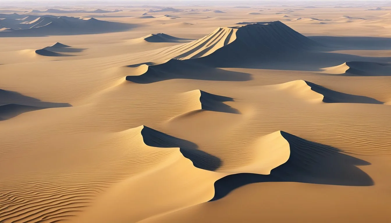
The Sahara Desert, often perceived as a barren expanse of sand, reveals astonishing evidence of ancient catastrophic flooding when viewed from above. Satellite imagery unveils massive current ripples spanning miles across the desert floor, particularly in western Mauritania, some 200 miles inland from the Atlantic coast. Unlike typical beach ripples measuring mere inches, these gigantic formations measure between three-quarters to one and a quarter miles apart, with heights reaching hundreds of feet.
These are not wind-formed sand dunes, but water-created ripples similar to those found on beaches—just at an incomparably larger scale. The presence of vast salt deposits throughout the region, especially in depressions and lower elevations, further supports the theory that seawater once covered these areas. While conventional science attributes these formations to the trans-Saharan Seaway from millions of years ago, emerging evidence suggests these dramatic landscape features may have been formed much more recently, challenging our understanding of Earth's geological history.
Key Takeaways
Massive current ripples in the Sahara Desert measure miles apart and hundreds of feet high, indicating catastrophic flooding on an unprecedented scale.
Extensive salt deposits throughout the Saharan region provide compelling evidence of ancient seawater that once covered and subsequently evaporated from the area.
These geological formations may be significantly younger than the conventional 50-100 million year timeline, potentially dating to just 11,000-12,000 years ago.
The Ocean Current Ripple Phenomenon

Sand ripples on beaches form through flowing water, creating distinctive patterns that reveal past water movement. These small formations, typically measuring only inches across, represent a microcosm of much larger geological processes. While beach ripples might seem insignificant, they connect to extraordinary formations found elsewhere on Earth that challenge our understanding of geological history and water's powerful shaping force.
Beach Ripples Compared to Desert Patterns
Beach ripples and desert patterns share remarkable similarities despite their vastly different scales. On beaches, water creates small ripples measured in inches, while in certain desert regions, similar patterns extend for miles. These geological formations follow fractal principles—the same patterns repeating at dramatically different scales.
The patterns visible in water-formed ripples differ significantly from wind-created sand dunes. This distinction becomes clear when comparing:
Feature Water-Formed Ripples Wind-Formed Sand Dunes Pattern Regular, wave-like formations Irregular, crescent-shaped Material Often expose bedrock beneath Pure sand accumulation Direction Aligned with water flow Oriented by prevailing winds Structure Symmetrical crests Asymmetrical slopes
Montana provides a fascinating intermediate example of these ripples. There, catastrophic flooding during the last ice age's end created ripples standing 50 feet tall and nearly 300 feet apart. Geological evidence suggests this required water flows approximately 1,000 feet deep—essentially a massive inland tsunami sweeping across the landscape.
Enormous Desert Ripples in the Sahara
In the western Sahara Desert, approximately 200 miles inland from the Atlantic coast of Mauritania, satellite imagery reveals truly massive ripple formations. These aren't sand dunes but rather water-erosion patterns so enormous they're measurable in miles:
The smallest ripples span about 3/4 mile apart
Most measure approximately one mile between crests
The largest formations reach 6,300 feet (1.25 miles) apart
These ripples stand approximately 200 feet tall—four times larger than Montana's impressive formations. Their scale suggests water flows of extraordinary magnitude moved across this region.
Evidence supporting a relatively recent formation (within the last 11,000-12,000 years) includes:
Salt deposits throughout the region, particularly in low-elevation areas where seawater would have pooled and evaporated
Salt mines near Nouakchott showing significant salt concentration visible from space
Depression patterns where salt accumulates, sitting hundreds of feet lower than surrounding terrain
Unlike traditional scientific explanations that attribute Saharan water features to the Trans-Saharan Seaway (56-66 million years ago), these distinctive ripple patterns and associated deposits suggest much more recent hydrological activity.
Evidence of Ancient Flood Events
Massive Ripple Formations in Western Sahara
Satellite imagery has revealed extraordinary geological features in the western Sahara Desert of Africa, approximately 200 miles inland from the Atlantic coast of Mauritania. These features appear as massive ripples in the landscape that strongly resemble current ripples found on beaches—except on a dramatically larger scale.
The ripple formations in Mauritania measure between three-quarters to one and a quarter miles apart (up to 6,300 feet). Unlike ordinary beach ripples that measure in inches, these enormous structures can only be properly viewed from space. Their immense scale suggests catastrophic water movement rather than typical erosion patterns.
These formations are distinct from sand dunes, which can be observed in nearby Namibia. While sand dunes and ripples may appear similar from a distance, closer examination reveals that the Mauritanian features display erosion patterns in bedrock typical of water movement, not wind-formed sand accumulations.
Comparative Analysis with Montana's Ripples
The Mauritanian ripples bear striking similarities to documented flood features in Montana, though at an even larger scale. The Montana ripples, created by catastrophic flooding during the melting of the North American ice sheet at the end of the last ice age, reach heights of approximately 50 feet—comparable to a five-story building—and are spaced about 300 feet apart.
Scientists studying the Montana formations have determined they resulted from tsunami-like water flows over 1,000 feet deep. By comparison, the Saharan ripples are approximately 200 feet tall with mile-wide spacing, suggesting even more powerful water movement.
Several lines of evidence suggest these Saharan flood events occurred relatively recently in geological terms—possibly within the last 11,000-12,000 years:
Salt deposits appear throughout the region, particularly:
At the Sepha salt mine near Nouakchott
Within the Richat Structure at low elevations
A 100-mile wide salt patch in the Eastern Sahara
These salt deposits consistently appear in depressions and lower elevations, suggesting they represent evaporated seawater that once covered these areas.
This evidence challenges conventional scientific estimates that place major water presence in the Sahara (the Trans-Saharan Seaway) at 56-66 million years ago or even earlier.
The Water Erosion Patterns of the Sahara
Salt Remnants Indicating Ancient Marine Presence
Salt deposits throughout the Sahara Desert provide compelling evidence of past seawater incursion. These are not simply random mineral formations but rather significant indicators of historical oceanic presence in what is now arid land. The salt trade has long been economically important across the region, utilizing these natural deposits.
Particularly notable salt concentrations appear in Mauritania, with the Sebkha salt mine near Nouakchott visible as white patches from satellite imagery. Similarly revealing are the salt deposits within the Richat Structure, consistently found at the lowest elevations. This positioning strongly suggests these are remnants of evaporated seawater that once settled in these depressions.
In the Eastern Sahara, an even more dramatic example exists: a nearly 100-mile-wide salt patch situated in a depression several hundred feet lower than surrounding terrain. The location of this salt deposit directly corresponds with visible water erosion patterns, reinforcing the connection between these formations and ancient seawater presence.
New Perspectives on Saharan Ripple Formations
Traditional scientific estimates place the Trans-Saharan Seaway between 56-66 million years ago, with some broader estimates suggesting 50-100 million years ago. However, recent evidence challenges these extensive timeframes with more immediate geological indicators.
The most striking features are the massive ripple patterns visible from satellite imagery, located more than 200 miles inland from Mauritania's Atlantic coast. Unlike typical beach ripples measuring in inches, these formations are extraordinary in scale:
Ripple Characteristics Measurements Small ripples ¾ mile apart Average ripples 1 mile apart Largest ripples 6,300 feet (1.25 miles) apart Height Approximately 200 feet
These formations differ significantly from sand dunes. For comparison, Namibia's massive coastal dunes demonstrate clear structural differences from the Saharan ripples. While dunes consist entirely of sand, these Saharan formations display water-eroded bedrock shaped into current ripples, similar to beach formations but at a dramatically larger scale.
The scale of these ripples suggests catastrophic water movement. When compared to the well-documented ripple formations in Montana—created by ice-age flooding and measuring 50 feet high with 300-foot spacing—the Saharan ripples indicate water flows of even greater magnitude than the thousand-foot deep flows that created the Montana features.
Critically, the positioning of salt deposits atop these ripple formations supports a more recent timeline than conventional estimates suggest, possibly within the last 11,000-12,000 years rather than tens of millions of years ago.
Geological Evidence of Ancient Water Flows

Scientific Verification of Massive Current Formations
The massive ripple patterns visible in satellite imagery of the western Sahara Desert have been analyzed by geologists who confirm these are not typical sand dunes but current ripples of extraordinary scale. While beach ripples typically measure in inches, these Saharan formations measure between 3/4 to 1-1/4 miles apart (approximately 4,000-6,300 feet). Their size suggests water flows of tremendous magnitude.
Renowned geological experts like Randall Carlson have examined these formations and verified their origin. The ripple patterns found in Mauritania, approximately 200 miles inland from the Atlantic coast, display characteristics consistent with water-formed features rather than wind-formed dunes. These formations parallel similar but smaller current ripples documented in Montana that were created by catastrophic ice-age flooding.
The Montana ripples, which reach heights of approximately 50 feet (comparable to a five-story building) and span about 300 feet apart, resulted from water flows estimated to be 1,000 feet deep. Using this as a reference point, the Saharan ripples—measuring up to 200 feet tall with mile-wide spacing—suggest water flows of even greater magnitude.
How to Differentiate Water-Formed Patterns from Wind-Formed Dunes
Comparison: Sand Dunes vs. Water Ripples
Feature Wind-Formed Sand Dunes Water-Formed Ripples Composition Pure sand accumulation Eroded bedrock with ripple patterns Pattern regularity Variable, less regular spacing Consistent, wave-like spacing Surface material Loose sand only May contain salt deposits from evaporated seawater Cross-section profile Asymmetrical with steeper slip face More symmetrical wave forms
The Namibian dunes provide an excellent comparison point as they're among Earth's largest sand formations and are conveniently located near the Atlantic coast. When examining these true dunes against the Saharan ripples, key differences become apparent in their formation and composition.
Salt deposits throughout the Sahara provide additional evidence of marine influence. Major salt accumulations appear precisely in the lowest elevations of these rippled areas, suggesting seawater once covered and subsequently evaporated from these regions. Notable examples include:
The Sebkha salt mine near Nouakchott
Salt deposits within the Richat Structure at its lowest elevations
A nearly 100-mile-wide salt patch in the Eastern Sahara that sits several hundred feet lower than surrounding terrain
These salt formations align with the water erosion patterns visible from satellite imagery, strengthening the case that massive water flows once shaped this now-arid landscape.
The Implications of the Remarkable Evidence
The discovery of enormous current ripples in the Sahara Desert presents extraordinary geological evidence that challenges conventional understanding of the region's history. These ripples, measuring up to 6,300 feet (1.25 miles) apart and standing hundreds of feet tall, dwarf the ordinary beach ripples that typically measure mere inches. Their scale is so vast that they're only truly visible from satellite imagery.
Located over 200 miles inland from the Atlantic coast of Mauritania, these formations cannot be dismissed as ordinary sand dunes. Unlike the massive sand dunes of Namibia, which are composed entirely of sand, these Saharan features display clear markers of water-eroded bedrock shaped into ripple patterns. The comparison to Montana's giant ripples, created by catastrophic ice age flooding, provides a useful reference point.
The Montana ripples, approximately 50 feet tall and 300 feet apart, resulted from water flows estimated at 1,000 feet deep. This raises profound questions about what magnitude of water movement would be required to create ripples four times taller and over five times farther apart in the Sahara.
Three key pieces of evidence suggest these formations occurred within the past 11,000-12,000 years, not millions of years ago as traditionally proposed:
Salt concentrations - Vast salt deposits throughout the region, including:
The Sebkha salt mine near Nouakchott
Salt deposits within the Richat Structure
A nearly 100-mile-wide salt patch in the Eastern Sahara
These salt deposits consistently appear in depressions and lower elevations, suggesting they are remnants of evaporated seawater that once flowed over the area.
The traditional scientific explanation attributes these water-formed features to the Trans-Saharan Seaway that existed 56-66 million years ago. However, this hypothesis features a troublingly imprecise timeframe (commonly estimated between 50-100 million years ago) and fails to account for evidence suggesting much more recent activity.
Most significantly, these geological features present a direct challenge to conventional timelines. If validated through further research, these findings would require a fundamental reconsideration of North African geological history and potentially significant revisions to our understanding of climate dynamics during the early Holocene period.