Ancient Roman Map Reveals Atlantis Location at Africa's Eye of the Sahara: New Evidence
Recent discoveries have shed new light on the intriguing connection between the Lost City of Atlantis and the Eye of the Sahara, also known as the Richat Structure, in Mauritania. This unique geological formation has captured attention due to its striking circular pattern that bears remarkable similarities to Plato's description of Atlantis. The structure remains scientifically enigmatic, with its distinctive concentric rings making it unlike any other formation on Earth.
Historical evidence strengthens this connection, including a 2,000-year-old map by Roman geographer Pomponius Mela that labels the region as "Atlantia." Geological studies reveal the Richat Structure was once a hydrothermal complex with hot springs, matching Plato's account. Additionally, ancient river systems connected the area to the Atlas Mountains in the north—namesakes of Atlantis's first king—while archaeological findings confirm the region's historical abundance of gold and elephants, both mentioned in classical descriptions of the legendary city.
Key Takeaways
The Eye of the Sahara matches Plato's description with concentric rings, specific colored stones, and a southern opening to the sea.
Historical maps from 2,000 years ago label this region of Northwest Africa as "Atlantia" or "Atlantier."
Scientific evidence confirms the area once had hydrothermal features, flowing rivers, and natural resources mentioned in classical accounts of Atlantis.
Revelation of the Saharan Eye and Ancient Atlantis Claims

Aligning with Plato's Ancient Account
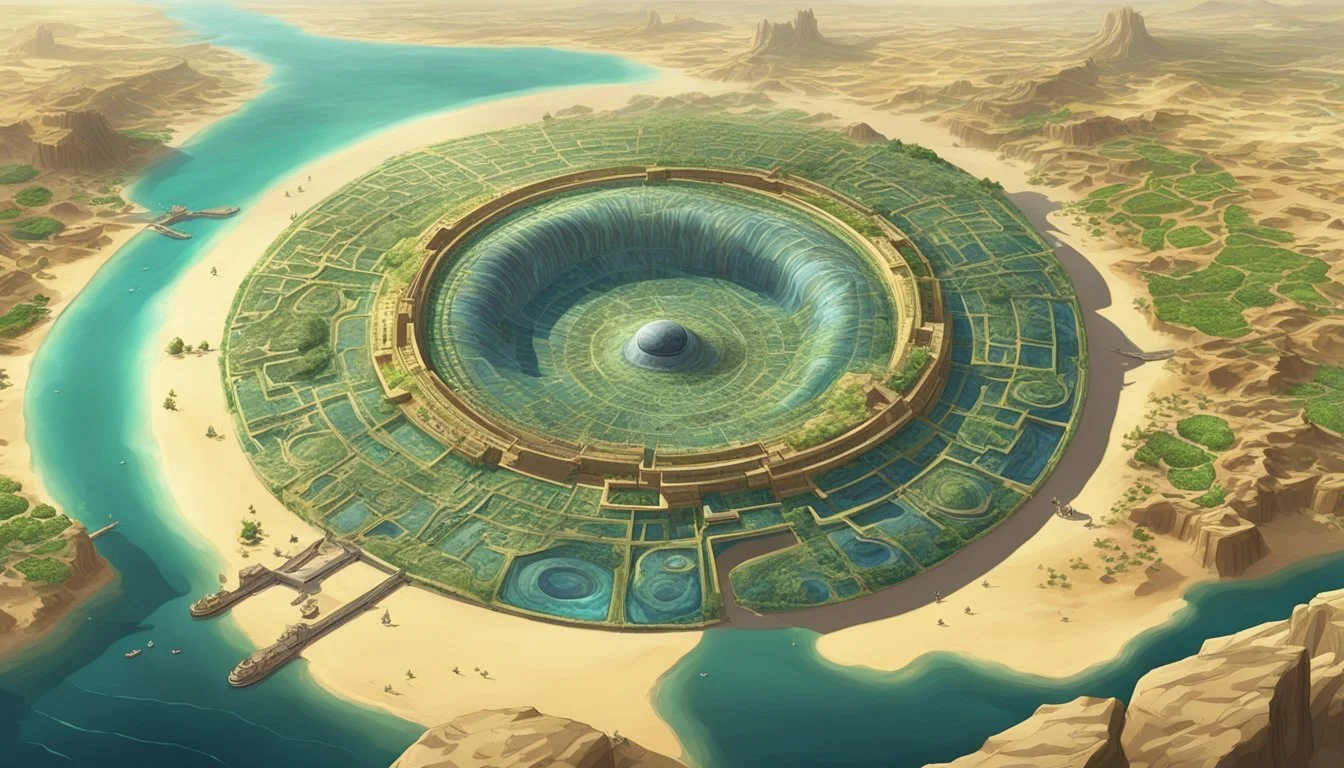
The Eye of the Sahara, also known as the Richat Structure, bears remarkable similarities to Plato's description of Atlantis. This unique geological formation features concentric rings that match Plato's account of three water rings and two land rings forming the capital city. The structure also displays a southern opening that corresponds with Plato's description of a sea channel.
The surrounding geography further strengthens this connection. A vast rectangular plain extends hundreds of miles around the structure, mirroring Plato's description of Atlantis' agricultural terrain. Notably, the Eye of the Sahara consists of rocks in black, red, and white colors—precisely the stone colors Plato attributed to Atlantis.
Recent Discoveries Supporting the Atlantis Hypothesis
A 2,000-year-old Roman map created by Pomponius Mela, Rome's first geographer, labels the region as "Atlantia" or "Atlantier." This ancient cartographic evidence places Atlanteans in the northwestern Sahara region where the Richat Structure exists today.
Historical records from 1851 document that ancient Mauritania possessed "considerable quantities" of gold and was Europe's primary gold source before America's discovery. The region also housed elephant populations, evidenced by nearby cave art depicting these animals—another detail matching Plato's description of Atlantis having numerous elephants.
Scientific studies from the late 1990s classify the Richat Structure as a hydrothermal complex, confirming it once contained hot springs. This perfectly aligns with Plato's description of Atlantis featuring both hot and cold springs at its center.
The Geological and Geographical Correspondence
The Atlas Mountains located north of the structure share their name with Atlas, the first king of both Mauritania and, according to legend, Atlantis. This naming parallel adds another layer to the geographical correspondence.
Plato's Atlantis Features Eye of the Sahara Characteristics Concentric circular rings Multiple visible concentric formations Southern sea opening Southern opening with salt water evidence Black, red, and white stones Geologically contains these three stone colors Mountains to the north Atlas Mountains to the north River systems Ancient Tamanrasset River flowed nearby
Recent scientific studies have confirmed the existence of an ancient river called the Tamanrasset that flowed from the Atlas Mountains through this region for approximately 500 kilometers to the Atlantic Ocean. This river would have passed directly through the area containing the Eye of the Sahara.
While currently dry and barren, geological evidence suggests this region had a dramatically different landscape 11,000-12,000 years ago—the timeframe Plato gave for Atlantis' existence.
Historical Maps and Ancient Atlantian References
The World According to Pomponius Mela
Roman documentation practices have left us with remarkable cartographic treasures from antiquity. Among these is a sophisticated geographical work created approximately 2,000 years ago by Pomponius Mela, considered Rome's first formal geographer. His map, titled "The Habitable World," represents one of the earliest comprehensive Roman attempts to document Earth's geography. This ancient map is oriented with east at the top in its original form, requiring modern viewers to rotate it for familiar north-south alignment.
When properly oriented, the map reveals recognizable features of Europe, West Asia, and North Africa. The document demonstrates the Romans' dedication to accumulating and preserving knowledge from across their empire. Pomponius Mela's work stands as evidence of early cartographic sophistication and the Roman commitment to geographical documentation.
Disputed Ancient Cartography
A separate and controversial map attributed to Herodotus from approximately 2,500 years ago has generated significant debate among scholars. This map purportedly depicts the "known world" of that era, but its authenticity remains contested. Modern historians question its origins, noting that Herodotus is not historically documented as having created physical maps.
The controversy surrounding this document centers on its mysterious source and provenance. Unlike the verifiably authentic Pomponius Mela map, the Herodotian cartography exists in a scholarly gray area. Despite these questions, the map has attracted attention for certain geographical notations that align with modern theories about ancient civilizations.
Mysterious "Atlantia" Marking in Northwest Africa
Perhaps the most intriguing aspect of the Pomponius Mela map is a specific annotation in the northwest region of the Sahara. The map clearly marks an area labeled "Atlantia" or "Atlantier" (appearing similar to "Atlanteans"). This designation appears in the geographical vicinity of today's Richat Structure in Mauritania.
This marking becomes particularly significant when considering the circular, concentric ring formation of the Richat Structure, which bears striking similarities to Plato's description of Atlantis:
Concentric circles: Three rings of water, two of land
Southern sea opening: Matches the Richat's southern breach
Evidence of saltwater flow: Still visible today
Surrounding rectangular plain: Extends for hundreds of miles
Distinctive stone colors: Black, red, and white geological features
The map's "Atlantia" notation, combined with these geographical similarities, presents a compelling connection between ancient Roman geographical knowledge and the mysterious eye-shaped formation in the Sahara desert. Historical literature from 1851 further notes that ancient Mauritania was rich in gold and elephant ivory—both resources specifically associated with Plato's Atlantis.
Historical Maps and Atlantean Traces

Pomponius Mela's Geographical Documentation
The Romans' meticulous approach to knowledge preservation gave rise to one of antiquity's most impressive maps created around 2,000 years ago. Pomponius Mela, recognized as Rome's pioneering geographer, developed "The Habitable World" – a sophisticated cartographic representation that documented the known territories of his era. This remarkable map originally presented east at the top, requiring reorientation for modern viewers accustomed to north-facing maps.
When properly aligned, the document clearly depicts recognizable landmasses including Europe, portions of Asia, and North Africa with surprising accuracy for its time. Mela's work exemplifies the Roman commitment to geographical documentation and serves as a valuable historical record of ancient geographical understanding.
Herodotus's Map Controversy
A separate cartographic document allegedly created by the Greek historian Herodotus approximately 2,500 years ago has sparked considerable academic debate. This contested map supposedly depicts the "known world" of that period but faces authenticity challenges from modern scholars who point out that Herodotus isn't historically recorded as having produced physical maps.
The document's uncertain origins have led many researchers to question its legitimacy as a primary historical source. Despite these controversies, the map has attracted attention for specific geographical annotations that seemingly align with certain archaeological discoveries. The ongoing scholarly examination of this document highlights the complexities involved in authenticating ancient cartographic works.
Atlantia Notation on the Roman Map
The Pomponius Mela map contains a particularly intriguing annotation in northwest Africa's Sahara region. The cartographer clearly marked an area labeled "Atlantia" or "Atlantier" (resembling "Atlanteans") in the approximate geographical location of today's Richat Structure in Mauritania.
This marking becomes especially significant when comparing the Richat Structure's distinctive features with Plato's description of Atlantis:
Plato's Description Richat Structure Characteristics Concentric circular design Multiple concentric rings visible from above Three water rings, two land rings Matching ring pattern Southern opening to the sea Southern breach in the formation Evidence of saltwater flow Still detectable today Rectangular surrounding plain Extends hundreds of miles in both directions Black, red, and white stones Matching geological composition
Historical documents from 1851 provide additional supporting evidence, noting ancient Mauritania's abundance of gold and elephant ivory – resources specifically associated with Plato's description of Atlantis. The region's geological characteristics include evidence of hydrothermal activity, potentially explaining Plato's references to hot springs.
Geological and Historical Connections

The Eye of Sahara's Distinctive Geological Features
The Richat Structure, commonly known as the Eye of Sahara, represents one of Earth's most fascinating geological phenomena. Unlike any other formation worldwide, this circular structure continues to perplex scientists with its unique composition and origin. The dome consists of distinctively colored rock layers—black, red, and white stones arranged in concentric circles.
Scientific studies from the late 1990s classified the Richat Structure as a hydrothermal complex. This classification supports the presence of ancient hot springs and thermal activity in the region. The formation's current arid appearance masks what was likely a water-rich environment approximately 11,000-12,000 years ago.
Research has revealed that ancient rivers once flowed through this region. The Tamanrasset River, stretching approximately 500 kilometers from the Atlas Mountains to the Atlantic Ocean, passed directly through the area where the Eye of Sahara now stands. This geological evidence suggests the structure once contained significant water channels.
Mining and Resources in Historical Mauritania
Mauritania's historical significance as a resource center remains underappreciated in modern discourse. Documentation from 1851 confirms the region possessed "gold in considerable quantities." These accounts note that before the discovery of the Americas, Europe relied heavily on Mauritanian gold supplies.
The region's natural wealth extended beyond precious metals:
Resource Historical Significance Gold Primary European supply pre-Columbus Elephant ivory Major export commodity Mineral deposits Diverse geological resources
Archaeological evidence supports this rich resource history. Cave art around the Richat Structure depicts elephants, confirming their historical presence in what is now desert terrain. This environmental transformation demonstrates how dramatically the region's climate has changed over millennia.
The Golden Empire of King Mansa Musa
Mansa Musa, ruler of the Mali Empire which encompassed modern-day Mauritania, stands as potentially the wealthiest individual in human history. His fortune dwarfed today's billionaires through his control of gold mines that accounted for more than half of the world's current gold supply.
The king's wealth stemmed directly from Mauritania's extraordinary gold deposits. This historical connection between the region and vast gold resources aligns with ancient accounts of resource-rich civilizations in Northwest Africa.
The Atlas Mountains to the north—named after the first king of Mauritania called Atlas—create another striking historical parallel. This name coincidentally matches the reported first king of Atlantis according to ancient texts, establishing an intriguing nomenclature connection between the region and legendary accounts.
Ancient Roman geographer Pomponius Mela documented this area approximately 2,000 years ago. His map of "the habitable world" specifically labeled a location in northwest Sahara as "Atlantia" or "Atlantier," positioned in the same geographical vicinity as the modern Richat Structure.
Biogeography and Ancient Evidence in Northwestern Africa
The geological formations of Northwestern Africa reveal fascinating connections to ancient human settlements. The eye-shaped Richat Structure in Mauritania presents unique geological characteristics found nowhere else on Earth. This circular formation, with its distinctive concentric rings, stands as one of the planet's most unusual natural features.
Archaeological evidence suggests human habitation in this region dates back thousands of years. Cave paintings discovered near the Richat Structure depict elephants and other wildlife, indicating a dramatically different climate in prehistoric times. These artistic records provide valuable insights into the region's former biodiversity.
Historical mapping reveals intriguing details about this area. A 2,000-year-old Roman geographical chart created by Pomponius Mela—the first known Roman geographer—labels a location in Northwestern Africa as "Atlantia" or "Atlantier." This ancient cartographic reference appears in the same general vicinity as the modern-day Richat Structure.
The region's geological composition features a striking combination of black, red, and white stone formations. Scientific studies from the late 1990s classified the Richat Structure as a hydrothermal complex, suggesting the previous existence of hot springs in the area. This finding aligns with evidence of ancient water sources in what is now arid desert.
Recent scientific research has confirmed the existence of an ancient river system called the Tamanrasset. This waterway once flowed approximately 500 kilometers from the Atlas Mountains to the Atlantic Ocean, passing through the area containing the Richat Structure. Such paleoenvironmental evidence demonstrates how dramatically the region's climate has changed.
Historical economic records from 1851 document Mauritania as a significant source of gold for European markets before the discovery of America. The region produced such abundant gold that Mansa Musa, a king whose territory included modern-day Mauritania, is considered by many historians to have been one of the wealthiest individuals in human history.
The Atlas Mountains to the north—named after the first known king of Mauritania—create a defining geographical boundary for the region. These mountains have played a crucial role in shaping the area's historical climate patterns and water systems.
Paleoclimatic research indicates that 11,000-12,000 years ago, Northwestern Africa experienced dramatically different environmental conditions. The currently arid Sahara region once supported diverse ecosystems with significantly more surface water and vegetation than exists today.
Physical evidence suggests ancient water channels flowed through the southernmost opening of the Richat Structure. Salt deposits remain visible today, indicating the historical presence of seawater in this now-desert location.
The comprehensive documentation of this region's natural resources extends beyond gold to include substantial elephant populations, as evidenced by both historical records and cave art. The abundance of ivory in ancient Mauritania is well-established in historical texts dating back centuries.
This convergence of geological, archaeological, and historical evidence presents a compelling case for reconsidering mainstream understandings of Northwestern Africa's ancient past. The unique features of the Richat Structure, combined with historical records and scientific findings, suggest this region may have played a more significant role in ancient human history than previously recognized.
Hydrothermal Features of the Richat Structure
The Richat Structure contains remarkable hydrothermal features that contribute to its geological uniqueness. Scientific studies from the late 1990s have classified this formation as a hydrothermal complex, confirming the presence of thermal activity in its geological history. These findings align with observations of distinctive geological characteristics not found elsewhere on Earth.
Evidence of both hot springs and cold freshwater springs has been documented within the structure. These thermal features would have been more active thousands of years ago when the climate of the region was significantly different from today's arid conditions.
The structure's composition includes distinctive black, red, and white colored stones, creating its characteristic multi-hued appearance. This unique geological makeup results from the hydrothermal processes that formed the structure over time.
Water once flowed abundantly through the Richat Structure, particularly entering from its southern opening. Scientific evidence confirms the presence of saltwater channels, with visible traces remaining to this day despite the current desert conditions.
The ancient Taman-Richat River system played a crucial role in the region's hydrology. This river flowed approximately 500 kilometers from the Atlas Mountains to the Atlantic Ocean, passing through the area of the Richat Structure and contributing to its water features.
The hydrothermal activity of the Richat Structure represents one of its most scientifically significant aspects, distinguishing it from other geological formations worldwide and contributing to ongoing scientific interest in this remote Saharan feature.
Climate and Landscape Dynamics
The Eye of the Sahara, also known as the Richat Structure, presents compelling geological evidence that challenges our understanding of North African climate history. This unique formation in Mauritania contains significant hydrogeological features indicating it once housed a complex water system. Scientific studies from the late 1990s classified it as a "hydrothermal complex," suggesting the presence of hot springs and cold freshwater sources that no longer exist in today's arid environment.
Recent research has uncovered evidence of ancient waterways in the region. Most notably, scientists have identified the Tamanrasset River, a massive waterway that once flowed approximately 500 kilometers from the Atlas Mountains to the Atlantic Ocean, passing directly through the area of the Eye of the Sahara. This river system would have dramatically transformed the landscape 11,000-12,000 years ago.
The geological composition of the Richat Structure features distinctive black, red, and white stone formations. These unique color patterns distinguish it from other geological formations worldwide and contribute to its scientific significance. The structure's concentric circles include what appears to be channels where water once flowed, with evidence of ancient saltwater movement still visible at its southern opening.
Northern Mauritania's topography is characterized by significant elevations, particularly the impressive Atlas Mountains. These mountains likely played a crucial role in the region's historical climate by influencing precipitation patterns and water drainage systems that fed the now-desert landscape.
The transformation from a water-rich environment to today's desert conditions represents one of Earth's most dramatic climate shifts. Scientific analysis of the area reveals that this region of the Sahara once supported diverse ecosystems, evidenced by cave art depicting elephants and other fauna no longer native to the area.
Natural resources in ancient Mauritania included substantial gold deposits. Historical records from 1851 mention "considerable quantities" of gold, noting that Europe received significant gold supplies from Mauritania before America's discovery. The Mali Empire, which included modern-day Mauritania, controlled gold mines that reportedly accounted for over half of the world's current gold supply.
This evidence collectively suggests the Eye of the Sahara existed within a dramatically different climate system thousands of years ago. The transformation from a hydrothermal, river-fed region to today's desert landscape demonstrates the profound climate changes that have occurred in North Africa over geological time.
Terrain Features and the Northern Mountains
Comparing Mountain Ranges
The northern region above the eye-shaped formation contains impressive mountain chains that provide crucial context for understanding the area's topography. The Atlas Mountains form a magnificent range extending across the northern territory, named after an ancient regional ruler. These mountains create a natural boundary and historically served as both protection and a resource-rich zone for the populations below them.
The Atlas range differs from the Adrar Highlands in scale and composition. While the Adrar formations could be considered substantial cliffs or elevated plateaus, the Atlas Mountains represent a true mountain chain with significantly higher elevations and different geological characteristics. The mountains display distinctive stone colorations including black, red, and white rock formations that match the geological patterns found in the circular structure below.
The Tamanrasett River Discovery
Recent scientific research has confirmed the existence of an ancient river system that once transformed the now-arid landscape. The Tamanrasett River flowed approximately 500 kilometers from the Atlas Mountains to the Atlantic Ocean, passing directly through the area containing the eye-shaped structure. This discovery dramatically changes our understanding of the region's historical geography.
The river created a fertile corridor that would have supported diverse ecosystems and human settlements along its path. Scientific studies from the late 1990s identified the circular structure as a hydrothermal complex, suggesting it once contained both hot springs and cold freshwater sources. These water features would have made the location particularly valuable for early inhabitants.
Evidence of the river's path remains visible today in satellite imagery and ground surveys, with traces of saltwater flow still detectable at the southern opening of the circular formation. This waterway would have connected the inland regions to the ocean, facilitating transportation and trade during periods when the Sahara experienced significantly more rainfall, approximately 11,000-12,000 years ago.
Conclusion
The evidence pointing to the Eye of the Sahara as the potential location of Atlantis is compelling when examined collectively. Ancient Roman maps from 2,000 years ago labeled this region "Atlantia" or "Atlantier," precisely where the Richat Structure exists today. This geological formation matches Plato's description with remarkable accuracy, featuring concentric circles and a southern opening that once connected to water.
Scientific studies have confirmed the Richat Structure's hydrothermal nature, aligning with Plato's mention of hot springs in Atlantis. The surrounding geology contains the black, red, and white stones described in ancient texts. Historical records from 1851 document Mauritania's abundance of gold and elephant ivory—resources specifically associated with Atlantis.
The presence of the Atlas Mountains to the north—named after the first king of Mauritania, who shares his name with Atlantis's first ruler—adds another layer of correlation. Recent research has identified an ancient river flowing from these mountains past the Eye of the Sahara to the Atlantic Ocean.
The geographical and geological evidence, combined with historical documentation, suggests this unique formation in Mauritania deserves serious consideration as the site of the legendary lost city. While today the region appears dry and barren, 11,000-12,000 years ago—during Atlantis's purported existence—the landscape would have been dramatically different, potentially supporting the advanced civilization described in ancient accounts.